Getting started
Exploring and using data
Exploring catalogs and datasets
Exploring a catalog of datasets
What's in a dataset
Filtering data within a dataset
An introduction to the Explore API
An introduction to the Automation API
Introduction to the WFS API
Downloading a dataset
Search your data with AI (vector search)
The Explore data with AI feature
Creating maps and charts
Creating advanced charts with the Charts tool
Overview of the Maps interface
Configure your map
Manage your maps
Reorder and group layers in a map
Creating multi-layer maps
Share your map
Navigating maps made with the Maps interface
Rename and save a map
Creating pages with the Code editor
How to limit who can see your visualizations
Archiving a page
Managing a page's security
Creating a page with the Code editor
Content pages: ideas, tips & resources
How to insert internal links on a page or create a table of contents
Sharing and embedding a content page
How to troubleshoot maps that are not loading correctly
Creating content with Studio
Adding a page
Publishing a page
Editing the page layout
Configuring blocks
Previewing a page
Adding text
Adding a chart
Adding an image block to a Studio page
Adding a map block in Studio
Adding a choropleth map block in Studio
Adding a points of interest map block in Studio
Adding a key performance indicator (KPI)
Configuring page information
Using filters to enhance your pages
Refining data
Managing page access
How to edit the url of a Studio page
Embedding a Studio page in a CMS
Visualizations
Managing saved visualizations
Configuring the calendar visualization
The basics of dataset visualizations
Configuring the images visualization
Configuring the custom view
Configuring the table visualization
Configuring the map visualization
Understanding automatic clustering in maps
Configuring the analyze visualization
Publishing data
Publishing datasets
Creating a dataset
Creating a dataset from a local file
Creating a dataset with multiple files
Creating a dataset from a remote source (URL, API, FTP)
Creating a dataset using dedicated connectors
Creating a dataset with media files
Federating an Opendatasoft dataset
Publishing a dataset
Publishing data from a CSV file
Publishing data in JSON format
Supported file formats
Promote mobility data thanks to GTFS and other formats
What is updated when publishing a remote file?
Configuring datasets
Automated removal of records
Configuring dataset export
Checking dataset history
Configuring the tooltip
Dataset actions and statuses
Dataset limits
Defining a dataset schema
How Opendatasoft manages dates
How and where Opendatasoft handles timezones
How to find your workspace's IP address
Keeping data up to date
Processing data
Translating a dataset
How to configure an HTTP connection to the France Travail API
Deciding what license is best for your dataset
Types of source files
OpenStreetMap files
Shapefiles
JSON files
XML files
Spreadsheet files
RDF files
CSV files
MapInfo files
GeoJSON files
KML/KMZ files
GeoPackage
Connectors
Saving and sharing connections
Airtable connector
Amazon S3 connector
ArcGIS connector
Azure Blob storage connector
Database connectors
Dataset of datasets (workspace) connector
Eco Counter connector
Feed connector
Google BigQuery connector
Google Drive connector
How to find the Open Agenda API Key and the Open Agenda URL
JCDecaux connector
Netatmo connector
OpenAgenda connector
Realtime connector
Salesforce connector
SharePoint connector
U.S. Census connector
WFS connector
Databricks connector
Connecteur Waze
Harvesters
Harvesting a catalog
ArcGIS harvester
ArcGIS Hub Portals harvester
CKAN harvester
CSW harvester
FTP with meta CSV harvester
Opendatasoft Federation harvester
Quandl harvester
Socrata harvester
data.gouv.fr harvester
data.json harvester
Processors
What is a processor and how to use one
Add a field processor
Compute geo distance processor
Concatenate text processor
Convert degrees processor
Copy a field processor
Correct geo shape processor
Create geo point processor
Decode HTML entities processor
Decode a Google polyline processor
Deduplicate multivalued fields processor
Delete record processor
Expand JSON array processor
Expand multivalued field processor
Expression processor
Extract HTML processor
Extract URLs processor
Extract bit range processor
Extract from JSON processor
Extract text processor
File processor
GeoHash to GeoJSON processor
GeoJoin processor
Geocode with ArcGIS processor
Geocode with BAN processor (France)
Geocode with PDOK processor
Geocode with the Census Bureau processor (United States)
Geomasking processor
Get coordinates from a three-word address processor
IP address to geo Coordinates processor
JSON array to multivalued processor
Join datasets processor
Meta expression processor
Nominatim geocoder processor
Normalize Projection Reference processor
Normalize URL processor
Normalize Unicode values processor
Normalize date processor
Polygon filtering processor
Replace text processor
Replace via regular expression processor
Retrieve Administrative Divisions processor
Set timezone processor
Simplify Geo Shape processor
Skip records processor
Split text processor
Transform boolean columns to multivalued field processor
Transpose columns to rows processor
WKT and WKB to GeoJson processor
what3words processor
Data Collection Form
About the Data Collection Form feature
Data Collection Forms associated with your Opendatasoft workspace
Create and manage your data collection forms
Sharing and moderating your data collection forms
Dataset metadata
Analyzing how your data is used
Getting involved: Sharing, Reusing and Reacting
Discovering & submitting data reuses
Sharing through social networks
Commenting via Disqus
Submitting feedback
Following dataset updates
Sharing and embedding data visualizations
Monitoring usage
An overview of monitoring your workspaces
Analyzing user activity
Analyzing actions
Detail about specific fields in the ods-api-monitoring dataset
How to count a dataset's downloads over a specific period
Analyzing data usage
Analyzing a single dataset with its monitoring dashboard
Analyzing back office activity
Using the data lineage feature
Managing your users
Managing limits
Managing users
Managing users
Setting quotas for individual users
Managing access requests
Inviting users to the portal
Managing workspaces
Managing your portal
Configuring your portal
Configure catalog and dataset pages
Configuring a shared catalog
Sharing, reusing, communicating
Customizing your workspace's URL
Managing legal information
Connect Google Analytics (GA4)
Regional settings
Pictograms reference
Managing tracking
Best practices for search engine optimization (SEO)
Look & Feel
Branding your portal
Customizing portal themes
How to customize my portal according to the current language
Managing the dataset themes
Configuring data visualizations
Configuring the navigation
Adding IGN basemaps
Adding images and fonts
Plans and quotas
Managing security
Configuring your portal's overall security policies
A dataset's Security tab
Mapping your directory to groups in Opendatasoft (with SSO)
Single sign-on with OpenID Connect
Single sign-on with SAML
Parameters
- Home
- Publishing data
- Configuring datasets
- How and where Opendatasoft handles timezones
How and where Opendatasoft handles timezones
Timezones: Essential, if potentially confusing
Agreeing on the time is usually simple because you and those around you all use the same reference. The sun comes up, and you drop your children at school on time. A restaurant isn't surprised by the lunch-hour rush.
But it takes 24 hours for the sun to rise and fall over the entire earth. With inventions like the telegraph or train we needed a way to all agree what time it was, but one that ensured people could continue expecting local events to occur around the same hour of the day, regardless of their location. Enter timezones, a late 19th-century invention balancing universal timekeeping with local consistency.
One look at a map of timezones, however, and you can see that the world is not clearly and evenly divided in 24 homogenous zones. Add to this seasonal changes such as "Daylight Saving Time," and different notations for time and timezones, and the need for precision and clarity become obvious.
The lesson? Timezones themselves can be confusing, but your data doesn't have to be. As a general rule, ensure your data is both correct and correctly formatted. But this is perhaps especially true when it comes to timezones.
Timezones in Opendatasoft
Timezones are present in several different places on the Opendatasoft platform.
Understanding how these timezones do or don't interact is critical, not only to display the correct dates and times to your users, but also to receive events and email alerts at the right time.
Timezones are found in four places:
- In datasets in your back office
- In datasets in your portal
- In your workspace's regional settings
- In the timezone used for scheduled updates to datasets
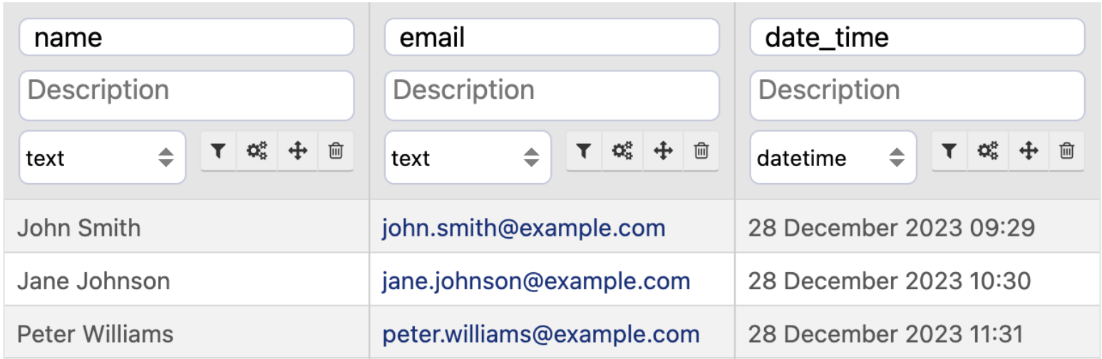
1) In datasets in your back office
In the back office, datasets are always displayed in UTC.
If the timezone is missing or incorrect, you can use the Set timezone processor to fix this.
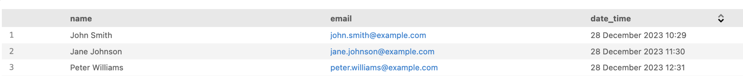
2) In datasets in your portal
In your portal, by default
By default, Opendatasoft uses your browser's timezone to display data in the portal (adjusted as necessary from the data's original timezone).
For example, if we remember that hours in the back office data are always in UTC:
Imagine it's December in Paris, France, and we're consulting this dataset in the portal.
In that case, the data would be indicated 1 hour later, since Paris at that time of the year is UTC+1:
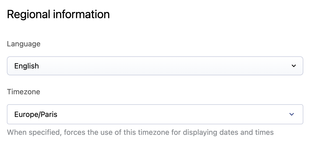
In your portal, if you specify a dataset's timezone in its metadata
If for whatever reason you need a dataset to be displayed using a different timezone, it is possible to override the default behavior.
Go to the dataset's Information tab, then its Standard metadata. There, under "Regional information" you can override the timezone for this dataset. This will modify the timezone used to display this dataset in the portal. Note that this does not modify the data, merely in what time zone the data is displayed.
3) In your workspace's regional settings
Your workspace's timezone determines the hour indicated in notification emails (reports and alerts).
For more information, see your Regional settings.
4) The timezone for scheduled updates
If applicable to your plan, timezones also are relevant to Scheduled updates.
Scheduled updates use the timezone in Paris, France. As such, they run on either GMT+1 (Central European Time) or GMT+2 (Central European Summer Time).
See here for more information.