
Your plan and quotas
Information about the pricing and plans available at Opendatasoft are on your plans page.
If you see License and not Plans in the left-hand menu, see this page.
To access the plans page, users must be granted the permission "Edit workspace properties."
To view the plans page, click on Plans in the left sidebar of your back office.
Viewing info related to your plan
On the second tab of the plans page (called Information), you will find details about your contract with Opendatasoft. These include your workspace's current plan, your plan's issue and expiration dates, your contact information, and how to reach the Opendatasoft team.
Main contact This field contains the email address of the main contact in your organization responsible for the workspace, and who will receive our maintenance or security alerts. The main contact is mandatory for a workspace. If you ever notice that the email address is not correct, contact our support team to have it updated.
Additional contacts These are other email addresses that you wish to include as security contacts and be sent the mailing list. Additional contacts are optional. Here too, if you need to edit this list, please contact the support team.
CSM contact The customer success manager in charge of helping you with your project.
Commercial contact Your main contact in case of questions related to your contract, pricing, or your plan's features.
Viewing plan subscriptions
The third tab gives you details about your plan's current options, as well as options available in other plans. Three distinct sections are displayed:
Platform plans
This part is a summary of the features included in each platform plan, and in particular which connectors are available to connect your favorite tools to Opendatsoft. The column for your current platform plan is highlighted.
Data plan
The data plan is about the data capacity you have on your platform (i.e. the max. dataset size and the total amount of structured published data—see below for the precise definitions). It's important to note that you can upgrade your data plan without changing your platform plan (for instance stay in the Starter Plan but obtain a larger maximum dataset size).
Add-ons
This last section informs you about the additional features (not included by default in your platform plan) that are currently activated on your workspace. For instance, you might have had activated the SSO (single sign-on) or the shared catalog.
Monitoring your quotas usage
Metrics related to your plan are called quotas. You can monitor the usage of your quotas on the first tab of the plans page.
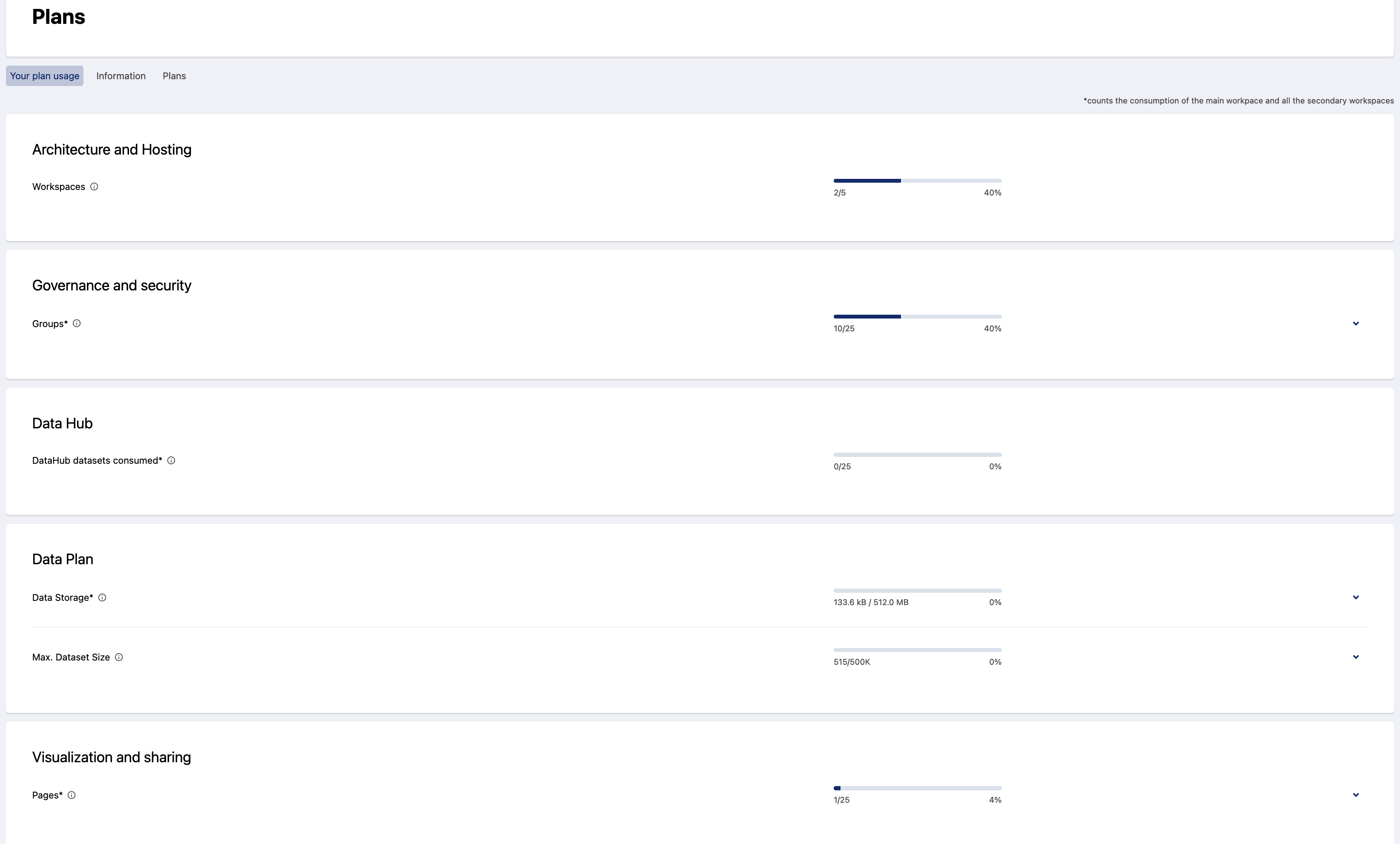
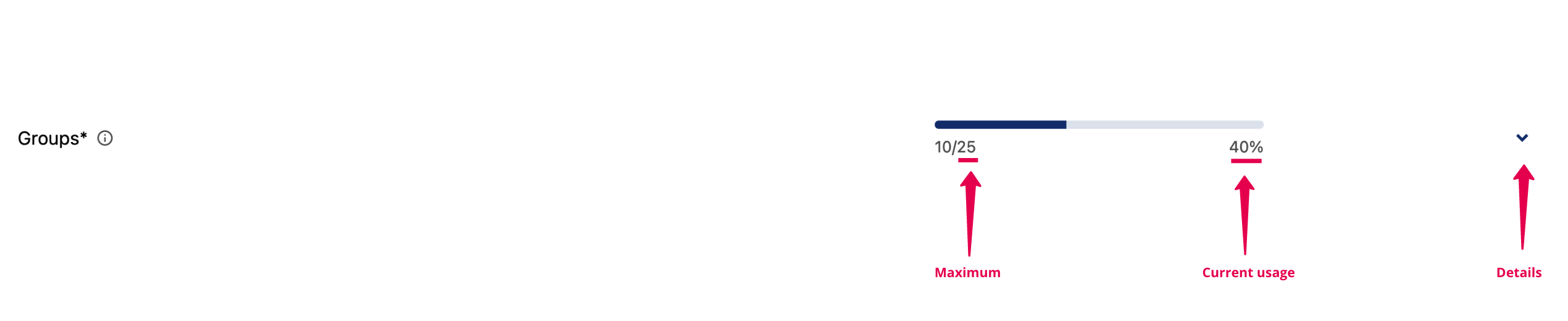
For each quota, you have a maximum value authorized in your plan (as well as packages you may have purchased in addition to the default value included in your plan), and your current consumption. By clicking on the chevron, or little up or down arrow, you can see details about your quota consumption.
Workspaces quota
What's counted in this quota? This quota counts all the workspaces. When the quota is reached, you cannot create additional groups.
What quota usage details can I see? The list shows you the last five secondary workspaces created.
You need to have the permission Manage secondary workspaces to see this list.
Groups quota
What's counted in this quota? This quota counts all the user groups, included the default groups. You can delete at any time the default groups to free slots in your user groups quota. When the quota is reached, you cannot created additional groups. Please note that only the Ultimate Plan allows you to have an unlimited number of user groups.
What quota usage details can I see? By clicking on the chevron, the list shows you the last five groups created.
Note that when you create a secondary workspace, a standard set of five groups is normally created (Content designers, Data publishers, Data users, Domain administrators, Service creators). However, if you have fewer than five free groups in your quota when creating a new workspace, if possible we will create only the groups Domain administrators and Data publishers, in that order, up to the limit of your quota.
Pages quota
What's counted in this quota? This quota counts all your published pages, so your published studio pages and unarchived HTML pages (by definition, an HTML page is either published or archived). The pages you have distributed on secondary workspaces count against the main workspace quota and not against the secondary workspaces pages quota. When the quota is reached, you cannot publish additional pages. But note that you can always unpublish pages to free slots in your pages quota.
What quota usage details can I see? By clicking on the chevron, the list shows you the last five published pages that were created. This allows you to see at glance which pages recently increased your quota.
You need to have the permission Edit all pages to see this list.
Maximum dataset size quota
What's counted in this quota? This quota, called "max. dataset size," represents the number of records contained in the dataset that contains the most records. When a dataset reaches this maximum size, any new publication or republication of the dataset is impossible.
What quota usage details can I see? By clicking on the chevron, the list shows you the five datasets with the most records. This allows you to see at glance which datasets will soon reach the maximum dataset size.
You need to have the permission Edit all datasets to see this list.
Published Structured Data (GB)
What's counted in this quota? This quota is calculated by summing up the size, in gigabytes, of all local datasets published on your platform. It is calculated after processing and enriching your data (e.g. adding geo shapes). When this quota is reached, any new publication or republication of local datasets is impossible.
What quota usage details can I see? By clicking on the chevron, the list shows you the five biggest datasets. This allows you to see at glance which datasets are mainly responsible for your consumption.
You need to have the permission Edit all datasets to see this list.
Data Hub datasets consumed
What's counted in this quota? This quota refers to the datasets used from the Opendatasoft Data Hub as part of an enrichment. It includes federation, harvesting, joins, use of the "Retrieve Administrative Divisions" and "GeoJoin" processors, or use of an export URL of a Data Hub dataset as source URL. When this quota is reached, any additional usage of datasets from the Data Hub is not possible. Please note that only the Ultimate Plan allows you to have an unlimited usage of our Data Hub.
What quota usage details can I see? By clicking on the chevron, the list shows you the datasets from the Data Hub that you are currently consuming. Also, by clicking on the number of uses on the right, you can see a dataset's consumers. This allows you to see at glance which datasets are using the Opendatasoft Data Hub.