 Getting started
 Exploring and using data
Exploring catalogs and datasets
Exploring a catalog of datasets
What's in a dataset
Filtering data within a dataset
An introduction to the Explore API
An introduction to the Automation API
Introduction to the WFS API
Downloading a dataset
Creating maps and charts
Creating advanced charts with the Charts tool
Overview of the Maps interface
Configure your map
Manage your maps
Reorder and group layers in a map
Creating multi-layer maps
Share your map
Navigating maps made with the Maps interface
Rename and save a map
Creating pages with the Code editor
How to limit who can see your visualizations
Archiving a page
Managing a page's security
Creating a page with the Code editor
Content pages: ideas, tips & resources
How to insert internal links on a page or create a table of contents
Sharing and embedding a content page
How to troubleshoot maps that are not loading correctly
Creating content with Studio
Creating content with Studio
Adding a page
Publishing a page
Editing the page layout
Configuring blocks
Previewing a page
Adding text
Adding a chart
Adding an image block to a Studio page
Adding a choropleth map block in Studio
Adding a points of interest map block in Studio
Adding a key performance indicator (KPI)
Configuring page information
Using filters to enhance your pages
Refining data
Managing page access
How to edit the url of a Studio page
Adding a map block in Studio
Visualizations
Managing saved visualizations
Configuring the calendar visualization
The basics of dataset visualizations
Configuring the images visualization
Configuring the custom view
Configuring the table visualization
Configuring the map visualization
Understanding automatic clustering in maps
Configuring the analyze visualization
 Publishing data
Creating a dataset
Creating a dataset from a local file
Creating a dataset with multiple files
Creating a dataset from a remote source (URL, API, FTP)
Creating a dataset using dedicated connectors
Creating a dataset with media files
Federating an Opendatasoft dataset
Publishing a dataset
Publishing data from a CSV file
Publishing data in JSON format
Supported file formats
Promote mobility data thanks to GTFS and other formats
Configuring datasets
Automated removal of records
Configuring dataset export
Checking dataset history
Configuring the tooltip
Dataset actions and statuses
Dataset limits
Defining a dataset schema
How Opendatasoft manages dates
How and where Opendatasoft handles timezones
How to find your workspace's IP address
Keeping data up to date
Processing data
Translating a dataset
How to configure an HTTP connection to the France Travail API
Deciding what license is best for your dataset
Types of source files
OpenStreetMap files
Shapefiles
JSON files
XML files
Spreadsheet files
RDF files
CSV files
MapInfo files
GeoJSON files
KML/KMZ files
GeoPackage
Connectors
Saving and sharing connections
Airtable connector
Amazon S3 connector
ArcGIS connector
Azure Blob storage connector
Database connector
Dataset of datasets (workspace) connector
Eco Counter connector
Feed connector
Google BigQuery connector
Google Drive connector
How to find the Open Agenda API Key and the Open Agenda URL
JCDecaux connector
Netatmo connector
OpenAgenda connector
Realtime connector
Salesforce connector
SharePoint connector
U.S. Census connector
WFS connector
Databricks connector
Harvesters
Harvesting a catalog
ArcGIS harvester
ArcGIS Hub Portals harvester
CKAN harvester
CSW harvester
FTP with meta CSV harvester
Opendatasoft Federation harvester
Quandl harvester
Socrata harvester
data.gouv.fr harvester
data.json harvester
Processors
What is a processor and how to use one
Add a field processor
Compute geo distance processor
Concatenate text processor
Convert degrees processor
Copy a field processor
Correct geo shape processor
Create geo point processor
Decode HTML entities processor
Decode a Google polyline processor
Deduplicate multivalued fields processor
Delete record processor
Expand JSON array processor
Expand multivalued field processor
Expression processor
Extract HTML processor
Extract URLs processor
Extract bit range processor
Extract from JSON processor
Extract text processor
File processor
GeoHash to GeoJSON processor
GeoJoin processor
Geocode with ArcGIS processor
Geocode with BAN processor (France)
Geocode with PDOK processor
Geocode with the Census Bureau processor (United States)
Geomasking processor
Get coordinates from a three-word address processor
IP address to geo Coordinates processor
JSON array to multivalued processor
Join datasets processor
Meta expression processor
Nominatim geocoder processor
Normalize Projection Reference processor
Normalize URL processor
Normalize Unicode values processor
Normalize date processor
Polygon filtering processor
Replace text processor
Replace via regular expression processor
Retrieve Administrative Divisions processor
Set timezone processor
Simplify Geo Shape processor
Skip records processor
Split text processor
Transform boolean columns to multivalued field processor
Transpose columns to rows processor
WKT and WKB to GeoJson processor
what3words processor
Data Collection Form
About the Data Collection Form feature
Data Collection Forms associated with your Opendatasoft workspace
Create and manage your data collection forms
Sharing and moderating your data collection forms
Dataset metadata
![]() Analyzing how your data is used
Analyzing how your data is used
Getting involved: Sharing, Reusing and Reacting
Discovering & submitting data reuses
Sharing through social networks
Commenting via Disqus
Submitting feedback
Following dataset updates
Sharing and embedding data visualizations
Monitoring usage
An overview of monitoring your workspaces
Analyzing user activity
Analyzing actions
Detail about specific fields in the ods-api-monitoring dataset
How to count a dataset's downloads over a specific period
Analyzing data usage
Analyzing a single dataset with its monitoring dashboard
Analyzing back office activity
Using the data lineage feature
 Managing your users
Managing limits
Managing users
Managing users
Setting quotas for individual users
Managing access requests
Inviting users to the portal
Managing workspaces
 Managing your portal
Configuring your portal
Configure catalog and dataset pages
Configuring a shared catalog
Sharing, reusing, communicating
Customizing your workspace's URL
Managing legal information
Connect Google Analytics (GA4)
Regional settings
Pictograms reference
Managing tracking
Look & Feel
Branding your portal
Customizing portal themes
How to customize my portal according to the current language
Managing the dataset themes
Configuring data visualizations
Configuring the navigation
Adding IGN basemaps
Adding assets
Plans and quotas
Managing security
Configuring your portal's overall security policies
A dataset's Security tab
Mapping your directory to groups in Opendatasoft (with SSO)
Single sign-on with OpenID Connect
Single sign-on with SAML
Parameters
Promote mobility data thanks to GTFS and other formats

The Opendatasoft value proposition for mobility data
Opendatasoft is designed to help you provide, share, and enrich data. It is designed so that organizations can allow non-experts to explore and make the most of their data.
It is not intended as a pass-through between two systems that produce or consume transportation data with complex formats, nor to replace a more specific mobility data solution. However, it is possible to share and showcase mobility data using Opendatasoft, publicly or even just within your organization.
This article dives deeper into what Opendatasoft allows you to do with mobility data.
Use Opendatasoft to make your mobility data available to non-specialists
Possibility #1: Make your static data available
You can make static data from your internal systems available for reuse by local actors and mobility stakeholders. This might be information on parking facilities, the location of self-service bike stations, or public transportation routes, and be made available in a variety of formats, such as CSV, JSON, Excel, SHP, and others.
Examples:
- Paris Velib bike-sharing stations
- Pau's bus lines (Idelis)
- Nantes' car-sharing stations
- Toulouse's tram stations
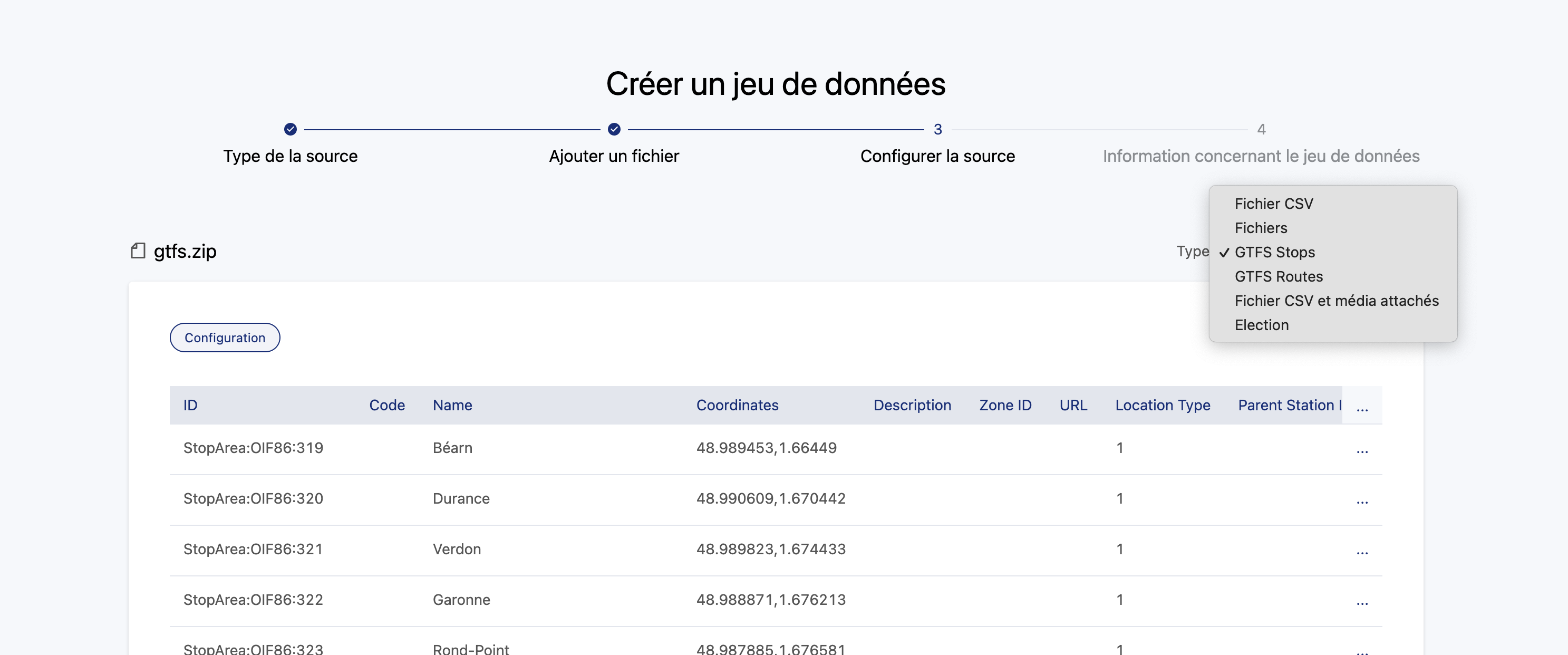
The lines and stops of a transport network (bus, tram, metro, train, etc.) can be made available from a GTFS file thanks to the GTFS connector. Contact our support if you wish to activate this connector on your account.
You won't see any change in the interface, though when importing a GTFS (.zip), but the data will be recognized and the connector selected by default. You can select for either stops or routes, as seen in the example below:
Possibility #2: Provide real-time data through our Explore API
You can provide real-time availability for self-service bicycles, parking spots, upcoming events, etc.
Examples:
Possibility #3: Provide network traffic data
Provide historical data on bike counts, pass validations at different stations, etc.
Examples:
Using interoperable transport data formats, such as GTFS(-RT), SIRI (Lite), NeTEx, etc.
As explained above, Opendatasoft is not designed to handle real-time transport information data and to make it usable at scale and with specialized transportation tools.
Opendatasoft does not provide a connector for these formats
As such, it's not possible to create a tabular Opendatasoft dataset from the data contained within a GTFS-RT, SIRI, or NeTEx file. Indeed, these formats are used by transportation applications to exchange data related to network disruptions and to update route planners. The data is structured in very specific ways and cannot be ingested as is by Opendatasoft. What's more:
- Processing this data in Opendatasoft would necessarily involve a delay between the production of the real-time data and the provision of the ODS dataset in the portal, defeating the purpose of having real-time data in the first place.
- Put simply, these formats are standards at a European or even global level, but the ODS Explore API is not. So if a developer has a service able to handle GTFS data, using the Opendatasoft Explore API to add further data would require further development.
Opendatasoft isn't trying to compete with a standard, but rather allow for as much interoperability as possible. Hence, it is still possible to make these files downloadable, as explained below.
How to make your transportation data files and APIs available to others
To expose transport data files and APIs, we suggest the following process:
- Create a dataset with a simple CSV as a source, listing the different type of files and APIs you're using.
- For the files (GTFS, NeTEx), add them as alternative exports either manually or, in the case where your file is automatically updated, you should provide the URL to download the file.Note that for transport.data.gouv.fr (the French National Access Point), there is a specific naming rule required to provide the data: The file name is not constrained, but the file's description must be either "Fichier GTFS" or "Fichier NeTXe".
- For the APIs you can add an alternative export and put the link to the API.Note that here again there is a naming rule for transport.data.gouv.fr: The description of the API should be "API GTFS-RT", "API GBFS", "API SIRI", or "API SIRI Lite".